Like property and investment management technology, satellite imagery capabilities and applications are constantly evolving. The Balance Sheet revisits a topic we first explored in 2017.
How can satellite imagery help improve business performance? The benefits can start with simple counting, as when Swiss investor UBS Investment Research started using space-based data to determine the population of Walmart parking lots about 10 years ago. The retail giant’s quarterly sales could be estimated from the number of cars entering and leaving the lots over periods of time. UBS thus was “one of the first financial institutions to leverage satellite imagery to gain useful investment insights,” notes Valerie Hernandez, writing in banking, finance and world affairs analysis  publication International Banker in June 2020. Other satellite imagery providers now count attendance at McDonald’s, Costco, Starbucks, Whole Foods and other retailers.
In the decade following UBS’s breakthrough, satellite technology evolved from a passive eye-in-the-sky to a predictor of corporate profits and a key analysis tool for the investment community. Data collected encompasses everything from solar-panel installations, sawmills’ lumber inventories, the number of cars produced at an auto plant and the mining of metals – all key metrics of business performance.
In fact, Hernandez says, “whether it’s counting cars in a retailer’s parking lot as a measure of sales activity, tracking ships across the seas, monitoring crops or scanning the activity at oil rigs, refineries and ports, satellite imagery is proving incredibly useful as a way to measure levels of industrial activity that may not necessarily be possible to determine at ground level.”
UC Berkeley law professor Frank Partnoy, writing in The Atlantic, recounts the derailment of a train carrying iron ore in Australia in November 2018: “Iron-ore prices soared on the news that the supply of a resource used in everything from furniture to paper clips could be interrupted. But some traders carefully analyzed satellite images of the accident and saw the ore piled in a flat area where it could easily be reloaded. They bet that prices would soon decline. They were right—within a couple of weeks the panic had subsided, and they had made a fortune.”
Property developers, for their part, use high-resolution satellite imaging to obtain data on conditions that affect building and landscape design, such as the impact of high-rise buildings on line-of-sight views, how much noise a construction project will add, and pedestrian movement and parking needs, among other things.
An advanced application of satellite imagery involves integrating machine-learning algorithms that combine car counts with data such as consumer transactions and spending patterns, oil-inventory levels and refinery outages with street maps, spectral data and even nighttime lighting and air pollution levels to give financial institutions an even more complete portrait of business performance.
Demand for satellite imagery from investors and other stakeholders continues to rise. That makes it likely, Hernandez writes, that “the number of actionable investment insights gleaned from such imagery will only grow, which should make generating returns a more competitive process.”
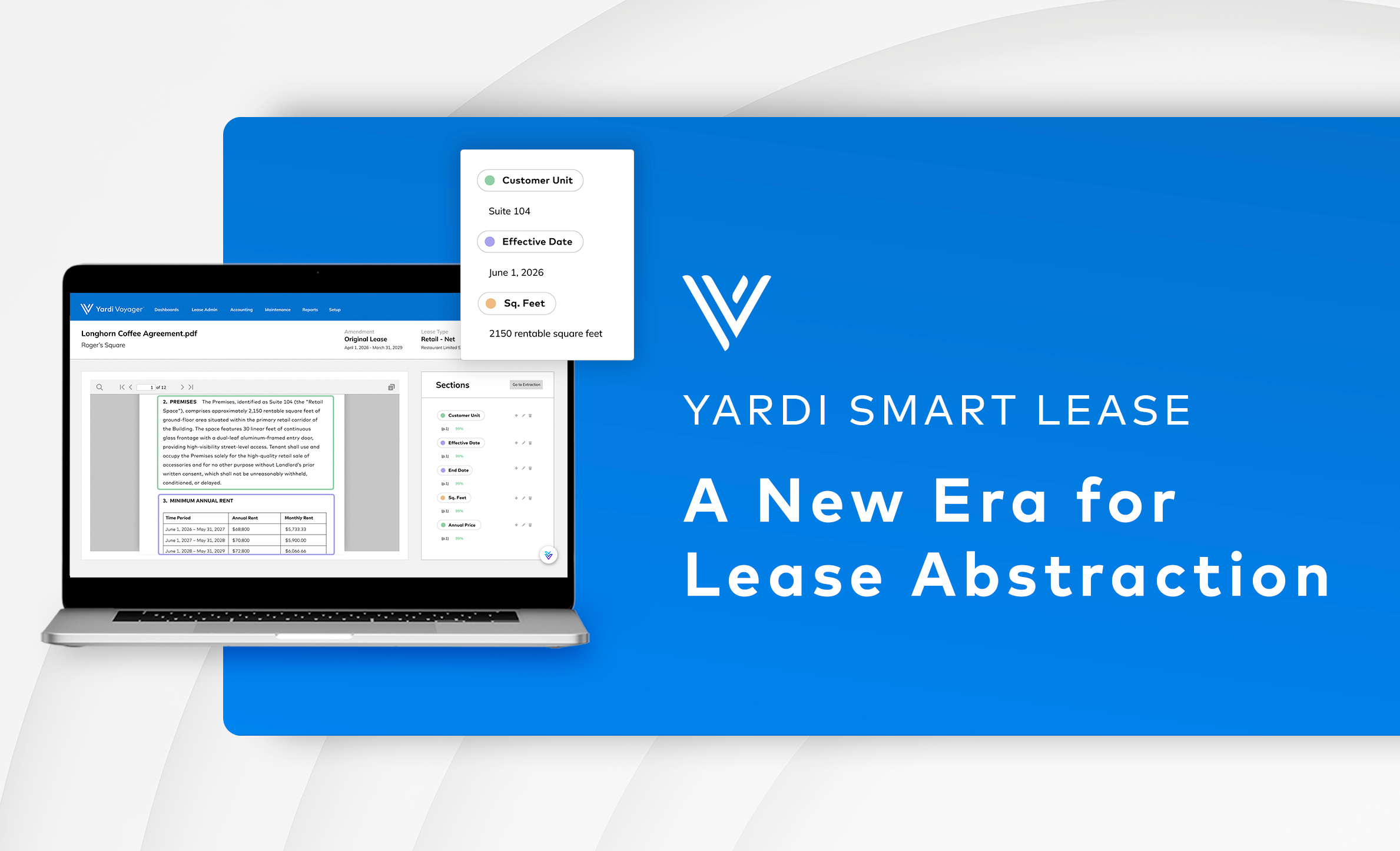
Real estate investment management software from Yardi also promotes competitive investment performance by automating accounting, performance measurement and financial reporting. Learn more.