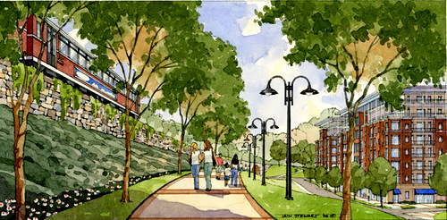
Atlanta’s BeltLine Apr16

Atlanta’s BeltLine

In the quest for a healthier, more transit-friendly Atlanta, a growing grassroots movement is backing the BeltLine plan. The Atlanta BeltLine, which includes 1,300 acres of parks, 33 miles of multi-use trails, 22 miles of rail transit, and 5,600 units of affordable housing, has grown from a seedling in the mind of a Georgia Tech student into a full-fledged redevelopment movement supported by civil leaders, residents, and national environmental organizations. Repurposed historic railway corridors and remediated brownfield make up the backbone of the BeltLine, accompanied by the addition of new parks and trails that unite various parts of the city into one, easily accessible whole. The BeltLine has caught the attention of multiple media outlets, and recently earned praise from The Sierra Club’s Smart Choices, Less Traffic report, where it was heralded as one of the nation’s finest examples of eco-conscious transportation initiatives. “If they pull it off, and I think they will, it will be a model, and pull them out of the economic doldrums they are in,” said Chris Leinberger, a leading scholar and expert on walkable urbanism. “The BeltLine is going to save the city of Atlanta and become a major economic generator for the entire region.” Most civic support has been poured into the transit lines. The BeltLine holds the ability to make the neighborhoods of Atlanta more accessible and united. A poorly developed public transit system and mind-numbing traffic (Atlanta tops Forbes’ “Worst Cities for Commuters List”)  currently locks residents within their neighborhoods and suburbs. To ease transportation woes, the BeltLine will connect 45 neighborhoods via rapid rail transit, merging with existing MARTA systems to extend access to the city’s suburbs. As each segment of the BeltLine reaches completion, more residents can enjoy abbreviated commute times. Improved public transit will also reduce Georgian’s dependency on personal motorized vehicles and the carbon footprint that they leave behind. While the transit line holds the greatest appeal for most Atlantans, it is also the source of the most contention. BeltLine progress has been vastly determined by referendums, the most recent of which failed to gain sufficient support. TSPLOST, which would have added a 1 percent sales tax to raise funds for portions of the project, was declined. Impeded but not deterred, leadership plows forward with the plan. Small victories, such as the recent Old Fourth Ward land acquisition, have kept the BeltLine vision alive. Earlier this year, Atlanta BeltLine Inc. purchased .76 acres of land from The Trust for Public Land. Though insubstantial in size, the space will make a huge impact on the BeltLine’s cohesion. The property will connect the new Eastside Trail with Historic Fourth Ward Park, allowing pedestrians a clear connection to Piedmont Park, Freedom Park Trail, and Jimmy Carter Presidential Library complex. Construction is slated for completion in 2014. Overtime, the Historic Old Fourth Ward property will connect with six existing parks. Researchers have realized that no single type of green space completes a snapshot of a healthier Atlanta, which is a secondary BeltLine goal. Walkability requires a combination of parks, urban gardens, playgrounds, woodlands, alternative transit routes and community plazas to develop an urban culture that is environmentally responsible and promotes residents’ physical and mental health. This spring, Atlanta BeltLine is collaborating with the City of Atlanta to replace the Edgewood Avenue bridge. Pedestrian walkways will be added to the new structure. By April 2014, the new Edgewood Avenue bridge will connect the Eastside Trail to Lake Avenue, DeKalb Avenue, and Irwin Street. This small link in the chain proves to be as important as any other, improving pedestrian access to multiple neighborhoods and their resources. To connect the various parks and residential corridors, a 33-mile network of multi-use trails is in the works. Fortunately for project planners, 22 miles of the trails were previously used for the railroad, thus offering relatively clear and maintained grounds upon which to build. Other portions...

RedPeak is Red Hot Feb19

RedPeak is Red Hot

Millennial renters want to live in urban neighborhoods with personality, ideally ones that are walkable, bikeable, and have shopping, service and entertainment amenities within a few blocks. Their desire for apartments in hip and up-and-coming city sectors is influencing multifamily development trends around the nation. An intensely local focus can be part of a great business plan as well as a way to meet consumer demand, and such an approach is serving Denver-based RedPeak Properties exceptionally well as the company grows in the city’s most popular neighborhoods. Not only is RedPeak solely focused on offering exceptional apartment experiences in the Denver area, but they are targeting the red-hot market for walkable urban neighborhoods, which are all the rage with young Colorado apartment renters. Apartment occupancy in Denver is at an 11-year high, and the city is a national leader in rent growth. Yardi client RedPeak celebrated its 10 year anniversary in 2012, and the company’s 15 multifamily properties will be joined by two new developments built from the ground up, as well as a renovation of a historic Denver hotel, in the next 12-24 months. To help meet the Denver demand for urban housing with fun things to do nearby, currently under construction in uptown Denver is RedPeak’s One City Block project (rendering, left), a mixed-use community with 302 apartment units that will encompass an entire city block. Sidewalk level retail encompasses 9,800 square feet, with tenants yet to be announced, but the commercial leases are in high demand. Residents will enjoy views of the city and the Rocky Mountains from one of four uniquely themed rooftop decks, and the project is being constructed according to Silver LEED certification standards. A second mixed-use project with 150 apartments, Highland Square, is planned for the popular...

Walkable Urbanism Feb05

Walkable Urbanism

Do you remember the last time you walked by a multifamily community under construction? Think carefully about the walking part, because it’s important.  Chances are, you were strolling in a city, not a suburb. Does anybody walk in the suburbs, other than to take the dog around the block? The answer to that question might hold the key to how development patterns will change, nationwide, over the next half-century. Apartment construction has bounced back big time, post-recession, and the hot spots for building are big cities with appeal to Millennials and Baby Boomers alike. Seattle, Portland, San Francisco, Los Angeles, Salt Lake City, Denver, Houston, Dallas, Chicago, Minneapolis, New York, Boston, and Washington D.C. “This is becoming a tale of two metro areas in this country: Those that get it, those that understand that walkable urban development is where the pent up demand is, and those that don’t. Any list of walkable metro areas that are doing well is also the list of best performing real estate markets,”  said Christopher Leinberger, the leading expert on the walkable urbanism trend. In some urban neighborhoods, developers can’t build fast enough to keep up with renter demand. What’s the secret? Not the old school adage “location, location, location.”  Leinberger, a senior fellow at Brookings Institute and professor at Georgetown University, describes it as closer to transit, transit, location. The research data he and his colleagues have produced on walkable urbanism has been of great interest to the media as the development cycle heats up. Having observed trends and nuance in real estate for several decades, he is perfectly positioned to explain the changing real estate development landscape. And it happens that the type of urban development he has long advocated for is now rolling out – and up – before our very eyes. “This is a major structural change, and I know there’s a lot of concern out there that this is just a blip,” he said, singling out the youngest group of apartment renters, the Millennials. They’ve been leading the demand for transit-friendly urban housing, and some observers think that once they’re ready to marry and have kids, they’ll flee the cities, heading back to the suburbs. Leinberger would strongly disagree. “We have just massively overbuilt. There’s only two ways of building the built environment – drivable suburban, and walkable urban. They are diametrically opposed as far as all the various characteristics you would use to describe them.  Both are market viable, so it’s not a value judgment as to one is better than the other. It’s that we built too much of the drivable suburban, because we’ve been doing that for 50-60 years. We have pent up demand for walkable urban.” Leinberger believes that the timespan for meeting that pent up demand is long – maybe even another half-century. So expect to keep walking by major development and redevelopment projects while you’re visiting your favorite cities.  And in the suburbs, there may start to be similar change – or consequences. “Get an anchor that’s walkable urban, and there will be an aura around that anchor that will help bolster (property) values,” is Leinberger’s advice to outlying, non-urban areas. Cities – even small ones – that can blend destination shopping and dining, services and offices, multifamily housing and public transit access all in the same area are planning well. His insight is more than academic.  Leinberger started his real estate career as managing director and co-owner of consulting film RCLCO (formerly Robert Charles Lesser & Co).  In addition to his academic work, he is President of LOCUS, a network of developers and investors who support and practice walkable urban development.  And to practice the philosophies he espouses, he and several partners founded Arcadia Land Company, which works on transit-focused, new urban projects. The changing multifamily development pattern is just one piece of the walkable urbanism puzzle. A more complete picture requires...