
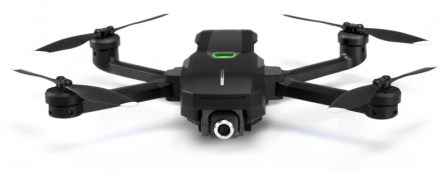
Drones have been increasingly popular in recent years, disrupting various industries with their aerial perspective. Until recently, the more professional models were prohibitively expensive, unless being purchased for a specific business venture. This summer saw the launch of a new drone that’s designed for the masses—Yuneec’s Mantis Q, a small, relatively powerful drone with a semi-reasonable price tag (about $500). Weighting a little over one pound, its in the sweet spot between budget drones like DJI’s Spark, and higher-end models like DJI’s Mavic Air. It holds in its 9 x 7 x 2 inch body (expanded) some of the features usually reserved for more sophisticated drones: 4K video recording, voice control, face detection, speed of up to 44 miles per hour and a lengthy 33-minute flight time. What’s more, it’s also equipped with infrared- and sonar-based stabilization and foldable arms that make it easy to shove in a backpack. The little drone has three automatic flight modes: journey mode—which flies on a straight, designated path; point of interest—which circles an assigned object; and return home—which automatically returns the drone near its takeoff area. In addition, sonar and infrared detection allow the drone to avoid obstacles and achieve stabilized flights indoors, without the aid of GPS. The face detection feature is said to recognize faces from up to 13 feet away and can take photos either through gesture control mode if the user waves their hand or through a voice command such as “Take a selfie.” Voice control can also be used to wake up the drone. We’re not sure how close one needs to be in order for the drone to hear the commands and how much environmental noise affects it. The range for video transmission is between 0.5 miles (800 meters) and 1...
Drones that Map
Applications for Real Estate
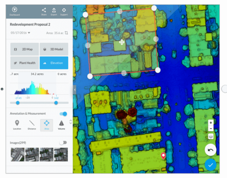
Last year was the most significant year for commercial drones yet. More than 66,000 remote drone pilots were certified by the FAA in 2017 in the U.S. alone. Drones made their way into a diverse range of industries, from archaeology to construction, insurance to agriculture. Of course, millions of dollars have been invested in drone services, but Goldman Sachs estimates that the commercial drone market industry will surpass $20 billion by 2021. One of the hottest drone products of the moment is the mapping service. DroneDeploy, a company founded in 2013, recently launched Live Map—the world’s first software able to generate drone maps in real time. Usually, creating a drone map takes time—first you have to plan a mission, fly, capture imagery, go back to your desk to upload the data on your computer (it must be a suitably powerful computer) and then play the waiting game. For hours. With the new service, those hours of waiting disappear—even without a laptop or even internet connection, you get the data you need immediately. The steps are simple: plan a flight, take off, look at maps render on-screen during flight. That’s it. Hundreds of acres of land can easily become consumable maps, shareable to collaborators via instant cloud-syncing across devices. Thus, if more in-depth analysis is required, users can also create higher-resolution 2D maps from the same flight data. Live Map is the next-generation product of Fieldscanner, but it’s five times faster, which makes it capable of keeping up with the real-time challenges of the real world. “Hours of waiting for crop imagery are over. We can capture real-time data in seconds without an internet connection, and begin making smarter crop management decisions before the drone hits the ground,” says Justin Metz, technology integration specialist at...
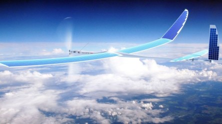
Project SkyBender
5G Network Delivered by Drone
Google’s playfulness in domains ruled by curiosity and ambition is never-ending. The giant seems to be working on a new and very secretive project dubbed SkyBender, as reported by The Guardian. This is a new Internet-in-the-sky program designed to bring the next-generation 5G network. Unlike Project Loon, but part of the Google Access team that includes the balloon project, SkyBender wants to use outfitted drones with millimeter wave transceivers. First, let’s have a look at these millimeter waves—they are longer than infrared waves or x-rays, but shorter than radio waves or microwaves. The millimeter wave region of the electromagnetic spectrum corresponds to radio band frequencies of 30GHz to 300GHz, sometimes called the Extremely High Frequency (EHF) range. These are thought to be the future of high-speed data transmission technology and the backbone of 5G mobile networks. Millimeter waves have a shorter range than that of the mobile phone signal, they fade sooner and are easily disrupted by weather conditions like rain, fog, and snow. However, using the so called phased array antennas and focused beams, Google and others could potentially focus the transmissions over greater distances. But this requires a lot more power. The FCC said that 5G millimeter wave networks could hit speeds between 1GBps and 10GBps, or up to 40 times more than today’s 4G LTE systems. In case you’re wondering why millimeter waves, Jacques Rudell, a professor of electrical engineering at the University of Washington in Seattle and specialist in this technology, justified to The Guardian: “The huge advantage of millimeter wave is access to new spectrum because the existing cellphone spectrum is overcrowded. It’s packed and there’s nowhere else to go”. Google is not the first to work with millimeter wave technology and drones. In 2014, DARPA—the research arm of...
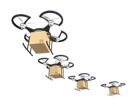
Drone Deliveries
Could be around the corner
Drones are unstoppable. Within the next one to three years we’ll receive our orders via drones if the private sector and government work hand in hand. Giants like Google and Amazon, and Wal-Mart have all announced working on developing their own fleet of drones to ship orders. The main setback remains the number of regulatory issues which need ironing out first. Currently, businesses interested in flying drones for commercial purposes need to seek approval from the Federal Aviation Administration on a case-by-case basis. Furthermore, under current drone rules, companies aren’t allowed to fly drones at night and drone operators can’t fly more than one drone at a time—well, except for the special show Intel prepared in collaboration with Ars Electronica Futurelab near Hamburg where four drone operators had each 25 drones under their command. You can watch the thing of beauty in the below video. Earlier this year, FAA Administrator Michael Huerta announced that the government plans to finalize its drone rules for commercial operations by late spring. The FAA enlisted a handful a drone makers, industry advocates, and retailers such as Google to help create the registration system and rules. The respective registration system came online in late December; since then 181,000 drones have been logged in its database. Google has been exploring the use of drones for deliveries over the past three years. Research continues under Dave Vos, head of Google X’s Project Wing experimental drone delivery program. At an aviation industry event in Washington, he stated that drones will be safer than general aviation and that they’ll operate quietly enough so as to not disturb anyone. According to Vos and his Jetsonian vision, people will eventually be transported from one point to another via autonomous airplanes. “Moving people and stuff around...